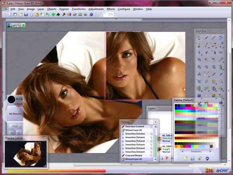
Chasys Draw IES is a suite of image editing applications including a layer-based image editor with animation, icon editing support and super-resolution via image stacking (Chasys Draw IES Artist), a multi-threaded image file converter (Chasys Draw IES Converter), a fast image viewer (Chasys Draw IES Viewer) and a RAW camera file processor (Chasys Draw IES raw-Photo). The whole suite is UAC aware and is designed to take advantage of multi-core processors, touch-screens and pen-input devices. Chasys Draw IES is built to adhere to three core principles, which I call the “three pillars” of Chasys Draw IES. Character: No photoshop imitations here. Performance: Fast, efficient and stable. Innovation: New techniques and out-of-the-box thinking.
Continue reading “Chasys Draw IES 5.33.01 Portable”
Month: February 2025
SRWare Iron 131.0.6650.1 Portable
The browser of the future – based on the free Sourcecode “Chromium” – without any problems at privacy and security. Google’s Web browser Chrome thrilled with an extremely fast site rendering, a sleek design and innovative features. But it also gets critic from data protection specialists, for reasons such as creating a unique user ID or the submission of entries to Google to generate suggestions. SRWare Iron is a real alternative. The browser is based on the Chromium-source and offers the same features as Chrome – but without the critical points that the privacy concern. We could therefore create a browser with which you can now use the innovative features without worrying about your privacy.
Continue reading “SRWare Iron 131.0.6650.1 Portable”
SAS.Planet 24.11.11 Final Portable
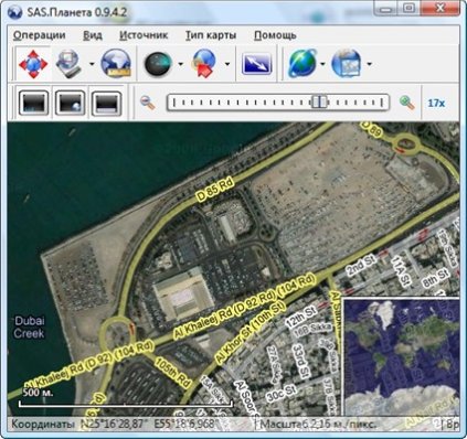
Geographic tool for view and download earth maps high definition such as Google Maps and satellite maps. Then you can see them offline. Compatible with OziExplorer. Fullscreen mode for viewing maps. SASPlanet – program designed for viewing and downloading high-resolution satellite imagery and conventional maps submitted by such services as Google Maps, DigitalGlobe, Yahoo! Maps, VirtualEarth, Gurtam, OpenStreetMap, iPhone maps, etc., but in contrast to all these services, all downloaded your card will remain on your computer, and you will be able to view them, even without connecting to the internet. In addition to satellite-based maps can work with the political landscape, the combined maps, and map the Moon and Mars.
Continue reading “SAS.Planet 24.11.11 Final Portable”